
Thank you for supporting this site ❤️
Make a donation
Make a donation
Gear up for your next adventure:
As an Amazon Associate, this site earns from qualifying purchases at no extra cost to you.
Utivé topographic map
Click on the map to display elevation.
Thank you for supporting this site ❤️
Make a donation
Make a donation
Gear up for your next adventure:
As an Amazon Associate, this site earns from qualifying purchases at no extra cost to you.
About this map
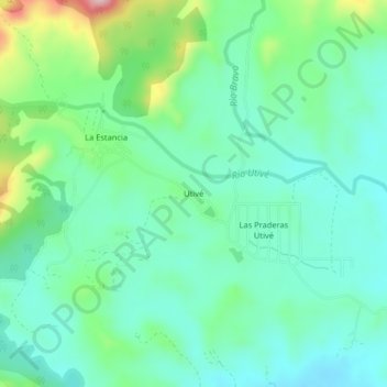
Name: Utivé topographic map, elevation, terrain.
Location: Utivé, Pacora, Distrito de Panamá, Panamá Province, Panama (9.13716 -79.34613 9.17716 -79.30613)
Average elevation: 92 m
Minimum elevation: 31 m
Maximum elevation: 270 m
Thank you for supporting this site ❤️
Make a donation
Make a donation
Gear up for your next adventure:
As an Amazon Associate, this site earns from qualifying purchases at no extra cost to you.