
Make a donation
Gear up for your next adventure:
As an Amazon Associate, this site earns from qualifying purchases at no extra cost to you.
Werschau topographic map
Click on the map to display elevation.
Make a donation
Gear up for your next adventure:
As an Amazon Associate, this site earns from qualifying purchases at no extra cost to you.
Werschau
Der alte Ortskern liegt rechts des Wörsbachs auf einer hochwasserfreien Anhöhe in Ufernähe. Am Nordrand des Orts verlaufen die A3 und die ICE-Strecke Frankfurt-Köln. Die Gemarkung weist nur ein kleines Waldstück am nordöstlichen Ortsrand auf und ist ansonsten von Landwirtschaftsfläche und einer großen Kiesgrube westlich des Orts geprägt. Die Siedlung selbst liegt auf 140 Metern Höhe. Zum Südwesten hin steigt die nur sanft hügelige Landschaft auf bis 200 Meter an.
Make a donation
Gear up for your next adventure:
As an Amazon Associate, this site earns from qualifying purchases at no extra cost to you.
About this map
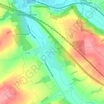
Name: Werschau topographic map, elevation, terrain.
Average elevation: 178 m
Minimum elevation: 131 m
Maximum elevation: 234 m
Make a donation
Gear up for your next adventure:
As an Amazon Associate, this site earns from qualifying purchases at no extra cost to you.