
Make a donation
Gear up for your next adventure:
As an Amazon Associate, this site earns from qualifying purchases at no extra cost to you.
Septmoncel topographic map
Click on the map to display elevation.
Make a donation
Gear up for your next adventure:
As an Amazon Associate, this site earns from qualifying purchases at no extra cost to you.
Septmoncel
Septmoncel se situe à 960 m d'altitude, à environ 4 km à vol d'oiseau au sud-est de la ville de Saint-Claude.
Make a donation
Gear up for your next adventure:
As an Amazon Associate, this site earns from qualifying purchases at no extra cost to you.
About this map
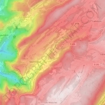
Name: Septmoncel topographic map, elevation, terrain.
Average elevation: 1,045 m
Minimum elevation: 440 m
Maximum elevation: 1,326 m
Make a donation
Gear up for your next adventure:
As an Amazon Associate, this site earns from qualifying purchases at no extra cost to you.
Other topographic maps
Click on a map to view its topography, its elevation and its terrain.
Les Moulins
France > Bourgogne-Franche-Comté > Jura > Septmoncel les Molunes
Average elevation: 1,018 m
Le Crêt Bolomy
France > Bourgogne-Franche-Comté > Jura > Septmoncel les Molunes
Average elevation: 1,008 m
Make a donation
Gear up for your next adventure:
As an Amazon Associate, this site earns from qualifying purchases at no extra cost to you.
La Couronne
France > Bourgogne-Franche-Comté > Jura > Septmoncel les Molunes
Average elevation: 1,080 m
La Vie Neuve
France > Bourgogne-Franche-Comté > Jura > Septmoncel les Molunes
Average elevation: 961 m
Cascade du Chapeau de Gendarme
France > Bourgogne-Franche-Comté > Jura > Septmoncel les Molunes
Average elevation: 975 m
Make a donation
Gear up for your next adventure:
As an Amazon Associate, this site earns from qualifying purchases at no extra cost to you.