Geolocate

Landwasser topographic map

Click on the map to display elevation.

About this map

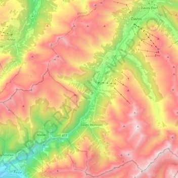
Name: Landwasser topographic map, elevation, terrain.

Location: Landwasser, Davos, Prättigau/Davos, Grisons, 7277, Switzerland (46.66934 9.66321 46.81109 9.84422)

Average elevation: 2,063 m

Minimum elevation: 963 m

Maximum elevation: 3,041 m

Other topographic maps

Click on a map to view its topography, its elevation and its terrain.

Davosersee

Switzerland > Grisons > Prättigau/Davos > Davos

Average elevation: 1,722 m

Clavadel

Switzerland > Grisons > Prättigau/Davos > Davos

Average elevation: 1,833 m

Jörihorn

Switzerland > Grisons > Prättigau/Davos > Davos

Average elevation: 2,557 m

Gear up for your next adventure:

🧣Merino Neck Gaiter - Protects against wind, sun, and cold at high altitudes
🛶Canoe Life Vest - Safety vest for water sports
💧Hydration Bladder - Hands-free hydration solution for long treks
🐕Hiking Dog Pack - Let your canine companion carry their own water and food
🥾Trekking Poles - Adjustable trekking poles to reduce knee stress and improve stability

As an Amazon Associate, this site earns from qualifying purchases at no extra cost to you.