Geolocate

Mount Ugo topographic map

Click on the map to display elevation.

About this map

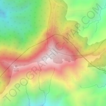
Name: Mount Ugo topographic map, elevation, terrain.

Location: Mount Ugo, Nueva Vizcaya, Cagayan Valley, Philippines (16.31932 120.80270 16.31942 120.80280)

Average elevation: 1,721 m

Minimum elevation: 1,271 m

Maximum elevation: 2,141 m

Other topographic maps

Click on a map to view its topography, its elevation and its terrain.

Kasibu River

Philippines > Nueva Vizcaya > Kasibu

Average elevation: 866 m

Kayapa

Philippines > Nueva Vizcaya

Average elevation: 1,258 m

Gear up for your next adventure:

🧥Insulated Jacket - Keep warm in cold outdoor conditions
Camping Groundsheet - Protect your tent from moisture and dirt
🥾Waterproof Trail Shoes - Shoes designed to handle wet terrain
🧴Sunscreen SPF - Broad-spectrum sunscreen for outdoor activities
🛶Waterproof Dry Bags - Keep electronics and clothes dry during river crossings

As an Amazon Associate, this site earns from qualifying purchases at no extra cost to you.