Geolocate

Gupa topographic map

Click on the map to display elevation.

About this map

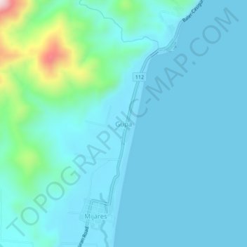
Name: Gupa topographic map, elevation, terrain.

Location: Gupa, Aurora, Central Luzon, Philippines (15.86917 121.53047 15.90917 121.57047)

Average elevation: 62 m

Minimum elevation: 0 m

Maximum elevation: 494 m

Other topographic maps

Click on a map to view its topography, its elevation and its terrain.

Dingalan

Philippines > Aurora

Average elevation: 249 m

Baler

Philippines > Aurora

Average elevation: 61 m

Dicasalarin Cove

Philippines > Aurora > Baler

Average elevation: 77 m

Dingalan River

Philippines > Aurora > Dingalan

Average elevation: 188 m

Aguang River

Philippines > Aurora > Baler

Average elevation: 36 m

Quezon Memorial Park

Philippines > Aurora > Baler > Sabang

Average elevation: 6 m

Umiray River

Philippines > Aurora > Dingalan > Abungan

Average elevation: 93 m

Casapsapan Beach

Philippines > Aurora > Casiguran > Dipasaleng

Average elevation: 22 m

Dingalan

Philippines > Aurora

Average elevation: 249 m

Dingalan

Philippines > Aurora

Average elevation: 249 m

Dingalan

Philippines > Aurora

Average elevation: 249 m

Baler

Philippines > Aurora

Average elevation: 61 m

Gear up for your next adventure:

🛌Down Sleeping Bag - Superior warmth-to-weight ratio for cold nights
🌡️Emergency Mylar Blankets - Compact thermal protection for unexpected nights outdoors
Camping Tent - Weather-resistant tents suitable for 2 to 6 people
🪑Insulated Seat Pad - Protect your seat from cold rocks and wet logs
🔋Emergency Crank Radio - Weather alerts and power without needing batteries

As an Amazon Associate, this site earns from qualifying purchases at no extra cost to you.