
Make a donation
Gear up for your next adventure:
As an Amazon Associate, this site earns from qualifying purchases at no extra cost to you.
Nelson topographic map
Click on the map to display elevation.
Make a donation
Gear up for your next adventure:
As an Amazon Associate, this site earns from qualifying purchases at no extra cost to you.
Nelson
Nelson is in the eastern part of Cheshire County, in southwestern New Hampshire. Its eastern border is the Hillsborough County line. According to the United States Census Bureau, the town has an area of 23.3 square miles (60.3 km2), of which 21.9 square miles (56.7 km2) are land and 1.4 square miles (3.5 km2) are water, comprising 5.88% of the town. The eastern part of town drains towards the Contoocook River, a tributary of the Merrimack River and part of the Gulf of Maine watershed, while the western part feeds tributaries of the Ashuelot River, part of the Connecticut River watershed draining to Long Island Sound. Spoonwood Pond and part of Nubanusit Lake are in the east. Part of Silver Lake is in the south, and part of Granite Lake is in the north. The village of Munsonville is at the outlet of Granite Lake. The highest point in Nelson is the summit of Osgood Hill (also known as Nelson Pinnacle), with an elevation of 2,253 feet (687 m) above sea level.
Make a donation
Gear up for your next adventure:
As an Amazon Associate, this site earns from qualifying purchases at no extra cost to you.
About this map
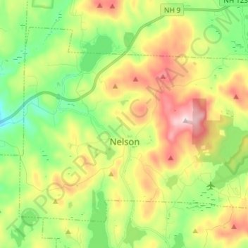
Name: Nelson topographic map, elevation, terrain.
Location: Nelson, Cheshire County, New Hampshire, 03457, United States (42.96124 -72.17963 43.03080 -72.05795)
Average elevation: 453 m
Minimum elevation: 305 m
Maximum elevation: 673 m
Make a donation
Gear up for your next adventure:
As an Amazon Associate, this site earns from qualifying purchases at no extra cost to you.
Other topographic maps
Click on a map to view its topography, its elevation and its terrain.
Mount Monadnock
United States > New Hampshire > Cheshire County > Jaffrey
From the base to the summit, floral species diminish with increasingly shallow soil levels. The summit is home to many different specialized sub-alpine species which can retain moisture for long periods of time. Alpine and sub-alpine species include mountain ash, cotton grass, sheep laurel, mountain sandwort,…
Average elevation: 687 m
Stone Pond
United States > New Hampshire > Cheshire County > Marlow > Gee Mill
Average elevation: 430 m
Make a donation
Gear up for your next adventure:
As an Amazon Associate, this site earns from qualifying purchases at no extra cost to you.
Camp Notre Dame
United States > New Hampshire > Cheshire County > Chesterfield
Average elevation: 223 m
Mount Monadnock
United States > New Hampshire > Cheshire County > Jaffrey
From the base to the summit, floral species diminish with increasingly shallow soil levels. The summit is home to many different specialized sub-alpine species which can retain moisture for long periods of time. Alpine and sub-alpine species include mountain ash, cotton grass, sheep laurel, mountain sandwort,…
Average elevation: 687 m
Make a donation
Gear up for your next adventure:
As an Amazon Associate, this site earns from qualifying purchases at no extra cost to you.
Mount Monadnock
United States > New Hampshire > Cheshire County > Jaffrey
From the base to the summit, floral species diminish with increasingly shallow soil levels. The summit is home to many different specialized sub-alpine species which can retain moisture for long periods of time. Alpine and sub-alpine species include mountain ash, cotton grass, sheep laurel, mountain sandwort,…
Average elevation: 687 m
Gilboa Mountain
United States > New Hampshire > Cheshire County > Westmoreland
Average elevation: 331 m
West Chesterfield
United States > New Hampshire > Cheshire County > Chesterfield
Average elevation: 168 m
Make a donation
Gear up for your next adventure:
As an Amazon Associate, this site earns from qualifying purchases at no extra cost to you.