Geolocate

Calmer topographic map

Click on the map to display elevation.

About this map

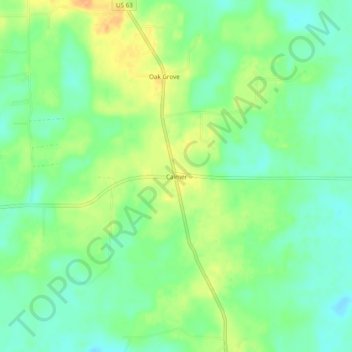
Name: Calmer topographic map, elevation, terrain.

Location: Calmer, Cleveland County, Arkansas, United States (33.91760 -92.05070 33.95760 -92.01070)

Average elevation: 69 m

Minimum elevation: 54 m

Maximum elevation: 87 m

Other topographic maps

Click on a map to view its topography, its elevation and its terrain.

Rison

United States > Arkansas > Cleveland County

Average elevation: 71 m

Gear up for your next adventure:

💡Portable Camping Lamp - Rechargeable lamp for campsite lighting
Backpacking Tent - Lightweight tent for long-distance hiking trips
🥾Waterproof Trail Shoes - Shoes designed to handle wet terrain
💧Hydration Bladder - Hands-free hydration solution for long treks
🛌Down Sleeping Bag - Superior warmth-to-weight ratio for cold nights

As an Amazon Associate, this site earns from qualifying purchases at no extra cost to you.