Geolocate

Combia topographic map

Click on the map to display elevation.

About this map

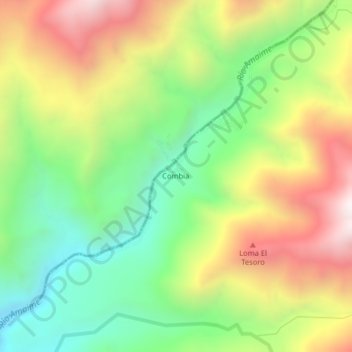
Name: Combia topographic map, elevation, terrain.

Location: Combia, Palmira, Sur, Valle del Cauca, RAP Pacífico, Colombia (3.66735 -76.05410 3.70735 -76.01410)

Average elevation: 2,512 m

Minimum elevation: 2,009 m

Maximum elevation: 3,169 m

Other topographic maps

Click on a map to view its topography, its elevation and its terrain.

Río Nima

Colombia > Valle del Cauca > Palmira

Average elevation: 1,300 m

Gear up for your next adventure:

🥾Trail Hiking Shoes - Durable shoes designed for rugged trails
🥾Hiking Gaiters - Protect legs and shoes from mud, snow, and debris
🦶Anti-Blister Balm - Prevents friction and hotspots during long ascents
🧰Survival Kit - Essential gear for emergencies in the wilderness
🕶️Polarized Sunglasses - Protect your eyes with durable polarized lenses

As an Amazon Associate, this site earns from qualifying purchases at no extra cost to you.