Geolocate

Crawford topographic map

Click on the map to display elevation.

About this map

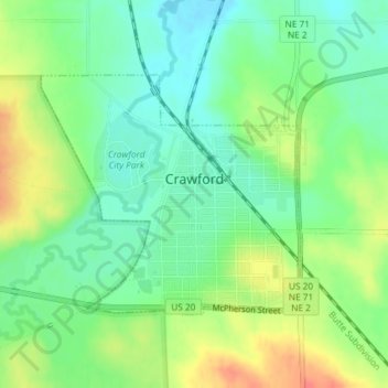
Name: Crawford topographic map, elevation, terrain.

Location: Crawford, Dawes County, Nebraska, United States (42.67725 -103.42786 42.69397 -103.40322)

Average elevation: 1,132 m

Minimum elevation: 1,110 m

Maximum elevation: 1,165 m

Other topographic maps

Click on a map to view its topography, its elevation and its terrain.

Lovers Leap

United States > Nebraska > Dawes County

Average elevation: 1,063 m

Gear up for your next adventure:

👖Convertible Hiking Pants - Zip-off legs to adapt to changing weather conditions
🚲Heavy Duty Bike Lock - Secure your bike at the trailhead or during stops
🛏️Sleeping Bag - Warm and compact sleeping bags for outdoor camping
🕶️Polarized Sunglasses - Protect your eyes with durable polarized lenses
🔋Emergency Crank Radio - Weather alerts and power without needing batteries

As an Amazon Associate, this site earns from qualifying purchases at no extra cost to you.