Geolocate

Acopalca topographic map

Click on the map to display elevation.

About this map

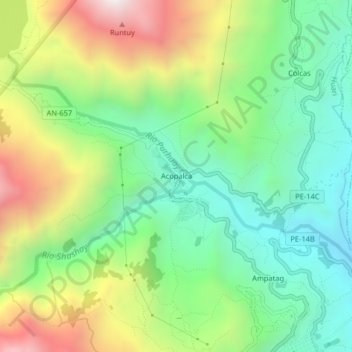
Name: Acopalca topographic map, elevation, terrain.

Location: Acopalca, Huari, Áncash, Perú (-9.34756 -77.20487 -9.30756 -77.16487)

Average elevation: 3,335 m

Minimum elevation: 2,886 m

Maximum elevation: 4,105 m

Other topographic maps

Click on a map to view its topography, its elevation and its terrain.

Huari

Perú > Áncash > Huari

Average elevation: 3,957 m

Gear up for your next adventure:

🥾Trail Running Boots - Durable shoes designed for trail running
🕶️Polarized Sunglasses - Protect your eyes with durable polarized lenses
🎒Hiking Daypack - Lightweight and durable backpacks for day trips and excursions
🧢Sun Protection Cap - Breathable cap to protect from sun exposure
💧Reusable Water Bottle - Durable water bottles for hydration on trails

As an Amazon Associate, this site earns from qualifying purchases at no extra cost to you.