
Make a donation
Gear up for your next adventure:
As an Amazon Associate, this site earns from qualifying purchases at no extra cost to you.
Chapaize topographic map
Click on the map to display elevation.
Make a donation
Gear up for your next adventure:
As an Amazon Associate, this site earns from qualifying purchases at no extra cost to you.
Chapaize
Het in 1030 gebouwde schip bestaat uit vijf traveeën op verschillend niveau. Het had oorspronkelijk een tongewelf. maar nadat dit in de 12e eeuw dreigde in te storten is het vervangen door het huidige geknikte tongewelf met gordelbogen (zie illustratie). Deze gordelbogen steunen aan de binnenkant op halfpijlers die zich verheffen boven de ronde hoofdpijlers, aan de buitenkant op steunberen die op halfpijlers staan. De buitenmuren hebben dezelfde constructie; halfpijlers verwerkt in het metselwerk op dikke ronde pijlers en uitwendige steunberen. Een en ander verleent het gebouw een perfecte architectonische eenheid. Oorspronkelijk was alle metselwerk bepleisterd met kalk; in de 20e eeuw is deze bedekking verwijderd. De oorspronkelijke nauwe vensteropeningen lieten maar weinig licht door. Waar mogelijk zijn ze in 1543 vergroot. Een opmerkelijk element is de gebeeldhouwde pijler, een van de oudste in het Westen, ter hoogte van de noordwand.
Make a donation
Gear up for your next adventure:
As an Amazon Associate, this site earns from qualifying purchases at no extra cost to you.
About this map
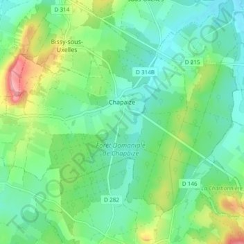
Name: Chapaize topographic map, elevation, terrain.
Average elevation: 234 m
Minimum elevation: 198 m
Maximum elevation: 321 m
Make a donation
Gear up for your next adventure:
As an Amazon Associate, this site earns from qualifying purchases at no extra cost to you.
Other topographic maps
Click on a map to view its topography, its elevation and its terrain.
Sous le Bois de Leynes
Frankrijk > Bourgondië-Franche-Comté > Saône-et-Loire > Leynes
Average elevation: 401 m
Labergement
Frankrijk > Bourgondië-Franche-Comté > Saône-et-Loire > Montpont-en-Bresse
Average elevation: 201 m
Les Gendrons
Frankrijk > Bourgondië-Franche-Comté > Saône-et-Loire > Tramayes
Average elevation: 469 m
Make a donation
Gear up for your next adventure:
As an Amazon Associate, this site earns from qualifying purchases at no extra cost to you.
La Charme
Frankrijk > Bourgondië-Franche-Comté > Saône-et-Loire > Ouroux-sur-Saône
Average elevation: 184 m
Sagy-le-Haut
Frankrijk > Bourgondië-Franche-Comté > Saône-et-Loire > Cruzille
Average elevation: 350 m
La Chavonnaise
Frankrijk > Bourgondië-Franche-Comté > Saône-et-Loire > Montpont-en-Bresse
Average elevation: 200 m
Make a donation
Gear up for your next adventure:
As an Amazon Associate, this site earns from qualifying purchases at no extra cost to you.
Les Pignots
Frankrijk > Bourgondië-Franche-Comté > Saône-et-Loire > Anost > Les Pignots
Average elevation: 598 m
Hameau du Château
Frankrijk > Bourgondië-Franche-Comté > Saône-et-Loire > Rully > Hameau du Château
Average elevation: 275 m
Make a donation
Gear up for your next adventure:
As an Amazon Associate, this site earns from qualifying purchases at no extra cost to you.
Mont Beuvray
Frankrijk > Bourgondië-Franche-Comté > Saône-et-Loire > Saint-Léger-sous-Beuvray
Average elevation: 632 m
Champagne
Frankrijk > Bourgondië-Franche-Comté > Saône-et-Loire > Culles-les-Roches
Average elevation: 357 m