Geolocate

Lenox topographic map

Click on the map to display elevation.

About this map

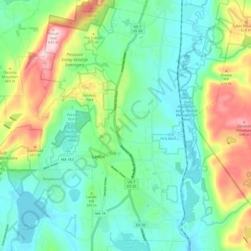
Name: Lenox topographic map, elevation, terrain.

Location: Lenox, Berkshire County, Massachusetts, United States (42.32354 -73.33363 42.41187 -73.22195)

Average elevation: 368 m

Minimum elevation: 276 m

Maximum elevation: 638 m

Other topographic maps

Click on a map to view its topography, its elevation and its terrain.

Gear up for your next adventure:

Backpacking Tent - Lightweight tent for long-distance hiking trips
🧥Softshell Hiking Jacket - The perfect balance of wind protection and breathability
🚲Handlebar Phone Mount - View topographic-map.com live while cycling
🧥Thermal Fleece Jacket - Versatile insulation for changing mountain temperatures
🪑Ultralight Camping Stool - Compact seating for rest stops during long hikes

As an Amazon Associate, this site earns from qualifying purchases at no extra cost to you.