
Make a donation
Gear up for your next adventure:
As an Amazon Associate, this site earns from qualifying purchases at no extra cost to you.
Lincoln topographic map
Click on the map to display elevation.
Make a donation
Gear up for your next adventure:
As an Amazon Associate, this site earns from qualifying purchases at no extra cost to you.
Lincoln
Lincoln is drained by the Pemigewasset River and its East Branch. Lincoln lies almost fully within the Merrimack River watershed, with the western edge of town in the Connecticut River watershed. Kancamagus Pass, elevation 2,860 feet (870 m), is on the Kancamagus Highway at the eastern boundary. The highest point in Lincoln is the summit of Mount Bond at 4,698 ft (1,432 m) above sea level.
Make a donation
Gear up for your next adventure:
As an Amazon Associate, this site earns from qualifying purchases at no extra cost to you.
About this map
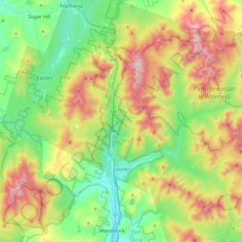
Name: Lincoln topographic map, elevation, terrain.
Location: Lincoln, Grafton County, New Hampshire, 03251, United States (44.00095 -71.77239 44.19788 -71.39812)
Average elevation: 677 m
Minimum elevation: 187 m
Maximum elevation: 1,582 m
Make a donation
Gear up for your next adventure:
As an Amazon Associate, this site earns from qualifying purchases at no extra cost to you.
Other topographic maps
Click on a map to view its topography, its elevation and its terrain.
Streeter Mountain
United States > New Hampshire > Grafton County > Dorchester
Average elevation: 449 m
Make a donation
Gear up for your next adventure:
As an Amazon Associate, this site earns from qualifying purchases at no extra cost to you.
Make a donation
Gear up for your next adventure:
As an Amazon Associate, this site earns from qualifying purchases at no extra cost to you.
The Village of Loon Mountain
United States > New Hampshire > Grafton County > Lincoln
Average elevation: 532 m
Make a donation
Gear up for your next adventure:
As an Amazon Associate, this site earns from qualifying purchases at no extra cost to you.
Make a donation
Gear up for your next adventure:
As an Amazon Associate, this site earns from qualifying purchases at no extra cost to you.
Make a donation
Gear up for your next adventure:
As an Amazon Associate, this site earns from qualifying purchases at no extra cost to you.
Stinson Lake
United States > New Hampshire > Grafton County > Rumney > Stinson Lake
Average elevation: 460 m
Make a donation
Gear up for your next adventure:
As an Amazon Associate, this site earns from qualifying purchases at no extra cost to you.
Mount Kineo, East Peak
United States > New Hampshire > Grafton County > Ellsworth
Average elevation: 710 m
LeBruns Mobile Home Park
United States > New Hampshire > Grafton County > Lebanon > LeBruns Mobile Home Park
Average elevation: 326 m
West Lebanon
United States > New Hampshire > Grafton County > Lebanon > West Lebanon
Average elevation: 165 m
Make a donation
Gear up for your next adventure:
As an Amazon Associate, this site earns from qualifying purchases at no extra cost to you.
North Littleton
United States > New Hampshire > Grafton County > Littleton > North Littleton
Average elevation: 333 m