
Thank you for supporting this site ❤️
Make a donation
Make a donation
Gear up for your next adventure:
As an Amazon Associate, this site earns from qualifying purchases at no extra cost to you.
Waltersdorf topographic map
Click on the map to display elevation.
Thank you for supporting this site ❤️
Make a donation
Make a donation
Gear up for your next adventure:
As an Amazon Associate, this site earns from qualifying purchases at no extra cost to you.
Waltersdorf
Waltersdorf liegt in Form eines Reihendorfs „inmitten einer reizvollen Wiesenlandschaft“ ganz im Süden des Gemeindegebietes. Der Ort liegt auf einer Höhe von 501 m ü. NN, Anhöhen reichen vereinzelt bis auf 583 Meter.
Thank you for supporting this site ❤️
Make a donation
Make a donation
Gear up for your next adventure:
As an Amazon Associate, this site earns from qualifying purchases at no extra cost to you.
About this map
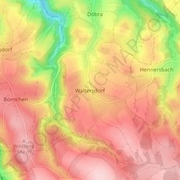
Name: Waltersdorf topographic map, elevation, terrain.
Average elevation: 517 m
Minimum elevation: 384 m
Maximum elevation: 595 m
Thank you for supporting this site ❤️
Make a donation
Make a donation
Gear up for your next adventure:
As an Amazon Associate, this site earns from qualifying purchases at no extra cost to you.