Geolocate

Lake View topographic map

Click on the map to display elevation.

About this map

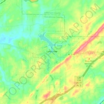
Name: Lake View topographic map, elevation, terrain.

Location: Lake View, Tuscaloosa County, Alabama, United States (33.26568 -87.15370 33.29468 -87.06887)

Average elevation: 174 m

Minimum elevation: 134 m

Maximum elevation: 236 m

Other topographic maps

Click on a map to view its topography, its elevation and its terrain.

Ralph

United States > Alabama > Tuscaloosa County

Average elevation: 60 m

South Ridge

United States > Alabama > Tuscaloosa County

Average elevation: 60 m

Bull City

United States > Alabama > Tuscaloosa County

Average elevation: 161 m

Carmel Bay

United States > Alabama > Tuscaloosa County

Average elevation: 82 m

Gear up for your next adventure:

🧰Multitool Knife - Compact and versatile tool for outdoor use
🥫Freeze-Dried Meals - Lightweight, high-calorie nutrition for multi-day treks
🧥Softshell Hiking Jacket - The perfect balance of wind protection and breathability
🎒Backpack Rain Cover - External shield to keep your entire pack dry
🥾Approach Shoes - Shoes designed for climbing approaches and rugged trails

As an Amazon Associate, this site earns from qualifying purchases at no extra cost to you.