Geolocate

Newai topographic map

Click on the map to display elevation.

About this map

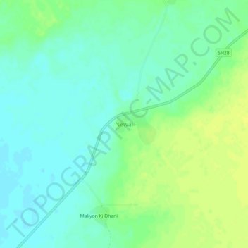
Name: Newai topographic map, elevation, terrain.

Location: Newai, Pachpadra Tehsil, Balotra, Rajasthan, India (25.96175 72.30451 26.00175 72.34451)

Average elevation: 120 m

Minimum elevation: 112 m

Maximum elevation: 129 m

Gear up for your next adventure:

Lightweight Backpacking Tent - Compact tent for efficient hiking trips
🧣Merino Neck Gaiter - Protects against wind, sun, and cold at high altitudes
💡LED Headlamp - Hands-free illumination for night hiking and camping
🔨Vehicle Emergency Tool - Safety tool for remote road trips to trailheads
🧢Beanie Hat - Keep your head warm in cold weather

As an Amazon Associate, this site earns from qualifying purchases at no extra cost to you.