
Le Rat topographic map
Interactive map
Click on the map to display elevation.
About this map
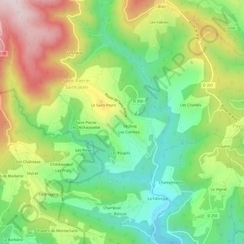
Name: Le Rat topographic map, elevation, terrain.
Average elevation: 358 m
Minimum elevation: 146 m
Maximum elevation: 668 m
Other topographic maps
Click on a map to view its topography, its elevation and its terrain.
Le Vidou
France > Auvergne-Rhône-Alpes > Ardèche > Saint-Pierre-Saint-Jean
Le Vidou, Le Pigeonnier, Saint-Pierre-Saint-Jean, Largentière, Ardèche, Auvergne-Rhône-Alpes, France métropolitaine, 07140, France
Average elevation: 335 m
Saint-Jean-de-Pourcharesse
France > Auvergne-Rhône-Alpes > Ardèche > Saint-Pierre-Saint-Jean
Saint-Jean-de-Pourcharesse, Saint-Pierre-Saint-Jean, Largentière, Ardèche, Auvergne-Rhône-Alpes, France métropolitaine, 07140, France
Average elevation: 663 m