
Make a donation
Gear up for your next adventure:
As an Amazon Associate, this site earns from qualifying purchases at no extra cost to you.
Bouches-du-Rhône topographic map
Click on the map to display elevation.
Make a donation
Gear up for your next adventure:
As an Amazon Associate, this site earns from qualifying purchases at no extra cost to you.
About this map
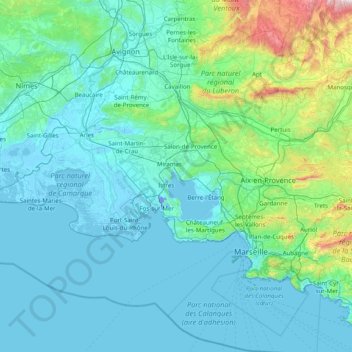
Name: Bouches-du-Rhône topographic map, elevation, terrain.
Average elevation: 154 m
Minimum elevation: -12 m
Maximum elevation: 1,658 m
Make a donation
Gear up for your next adventure:
As an Amazon Associate, this site earns from qualifying purchases at no extra cost to you.
Other topographic maps
Click on a map to view its topography, its elevation and its terrain.
Plage du Canon
France > Provence-Alpes-Côte d'Azur > Var > Saint-Mandrier-sur-Mer
Average elevation: 18 m
Serre Chevalier
France > Provence-Alpes-Côte d'Azur > Hautes-Alpes > Puy-Saint-André
The maximum elevation for skiing is at Telesiege Yret at 2,800 m (9,190 ft) above sea level, and the minimum is 1,200 m (3,940 ft), a total vertical drop of 1,600 m (5,250 ft). One of the outstanding features of Serre Chevalier is the wooded nature of the slopes. The timber line is at 2,150 m (7,050 ft),…
Average elevation: 2,256 m
La Gravette
France > Provence-Alpes-Côte d'Azur > Alpes-de-Haute-Provence > Barcelonnette
Average elevation: 1,282 m
Make a donation
Gear up for your next adventure:
As an Amazon Associate, this site earns from qualifying purchases at no extra cost to you.
Mont Puget
France > Provence-Alpes-Côte d'Azur > Bouches-du-Rhône > Marseille
Average elevation: 289 m
Col du Lautaret
France > Provence-Alpes-Côte d'Azur > Hautes-Alpes > Le Monêtier-les-Bains
From the west, the climb starts at Les Clapier, near Le Bourg-d'Oisans, from where the climb is 34.2 km (21.3 mi) long, gaining 1,312 m (4,304 ft) in altitude, at an average gradient of 3.8%, with the steepest section being at 7.5% in the first kilometre.
Average elevation: 2,261 m
Cime de la Bonette
France > Provence-Alpes-Côte d'Azur > Maritime Alps > Saint-Dalmas-le-Selvage
Average elevation: 2,512 m
Make a donation
Gear up for your next adventure:
As an Amazon Associate, this site earns from qualifying purchases at no extra cost to you.
Crête de l'Estret
France > Provence-Alpes-Côte d'Azur > Bouches-du-Rhône > Marseille
Average elevation: 307 m
Lucis
France > Provence-Alpes-Côte d'Azur > Hautes-Alpes > Villar-Saint-Pancrace
Average elevation: 1,326 m
Pont du Loup
France > Provence-Alpes-Côte d'Azur > Maritime Alps > Tourrettes-sur-Loup
Average elevation: 607 m
Berne
France > Provence-Alpes-Côte d'Azur > Var > Saint-Maximin-la-Sainte-Baume
Average elevation: 512 m
Make a donation
Gear up for your next adventure:
As an Amazon Associate, this site earns from qualifying purchases at no extra cost to you.
Le Villardon
France > Provence-Alpes-Côte d'Azur > Hautes-Alpes > Aubessagne
Average elevation: 1,063 m
Orcières-Merlette
France > Provence-Alpes-Côte d'Azur > Hautes-Alpes > Orcières
Average elevation: 1,874 m
Plan de la Loubiere
France > Provence-Alpes-Côte d'Azur > Hautes-Alpes > La Roche-de-Rame
Average elevation: 2,056 m
Make a donation
Gear up for your next adventure:
As an Amazon Associate, this site earns from qualifying purchases at no extra cost to you.
Puget-sur-Argens
France > Provence-Alpes-Côte d'Azur > Var > Puget-sur-Argens > Puget-sur-Argens
Average elevation: 20 m
Make a donation
Gear up for your next adventure:
As an Amazon Associate, this site earns from qualifying purchases at no extra cost to you.
Grotte des Tuves
France > Provence-Alpes-Côte d'Azur > Var > Saint-Cézaire-sur-Siagne
Average elevation: 362 m
Make a donation
Gear up for your next adventure:
As an Amazon Associate, this site earns from qualifying purchases at no extra cost to you.
Chaumie Bas
France > Provence-Alpes-Côte d'Azur > Alpes-de-Haute-Provence > Chaumie
Average elevation: 1,677 m
Digne-les-Bains
France > Provence-Alpes-Côte d'Azur > Alpes-de-Haute-Provence > Digne-les-Bains > Digne-les-Bains
Average elevation: 791 m
Port-de-Bouc
France > Provence-Alpes-Côte d'Azur > Bouches-du-Rhône > Port-de-Bouc > Port-de-Bouc
Average elevation: 12 m
Make a donation
Gear up for your next adventure:
As an Amazon Associate, this site earns from qualifying purchases at no extra cost to you.
La Ciotat
France > Provence-Alpes-Côte d'Azur > Bouches-du-Rhône > La Ciotat > La Ciotat
Average elevation: 57 m
Forte Colle Alto
France > Provence-Alpes-Côte d'Azur > Maritime Alps > Tende
Average elevation: 1,688 m
Make a donation
Gear up for your next adventure:
As an Amazon Associate, this site earns from qualifying purchases at no extra cost to you.
La Seyne-sur-Mer
France > Provence-Alpes-Côte d'Azur > Var > La Seyne-sur-Mer > La Seyne-sur-Mer
Average elevation: 35 m
Roya
France > Provence-Alpes-Côte d'Azur > Maritime Alps > Saint-Étienne-de-Tinée > Roya
Average elevation: 1,857 m
Saint-Ours
France > Provence-Alpes-Côte d'Azur > Alpes-de-Haute-Provence > Val-d'Oronaye > Saint-Ours
Average elevation: 2,031 m
Ouvrage de Haut-Saint-Ours
France > Provence-Alpes-Côte d'Azur > Alpes-de-Haute-Provence > Val-d'Oronaye > Saint-Ours
Average elevation: 1,929 m
Make a donation
Gear up for your next adventure:
As an Amazon Associate, this site earns from qualifying purchases at no extra cost to you.
Les Chaussendents
France > Provence-Alpes-Côte d'Azur > Hautes-Alpes > La Chapelle-en-Valgaudémar
Average elevation: 1,619 m
Beaumont du Ventoux
France > Provence-Alpes-Côte d'Azur > Vaucluse > Beaumont-du-Ventoux
Average elevation: 501 m
Avignon
France > Provence-Alpes-Côte d'Azur > Vaucluse > Avignon
Enclosed by the city walls, the Rocher des Doms is a limestone elevation of Urgonian type, 35 metres high (and therefore safe from flooding of the Rhone which it overlooks) and is the original core of the city. Several limestone massifs are present around the commune (the Massif des Angles,…
Average elevation: 58 m
Make a donation
Gear up for your next adventure:
As an Amazon Associate, this site earns from qualifying purchases at no extra cost to you.
Make a donation
Gear up for your next adventure:
As an Amazon Associate, this site earns from qualifying purchases at no extra cost to you.
Fort du Grand-Saint-Antoine
France > Provence-Alpes-Côte d'Azur > Var > Toulon
Average elevation: 121 m
Embut de la Plaine des Enfers
France > Provence-Alpes-Côte d'Azur > Var > Cuges-les-Pins
Average elevation: 564 m
Make a donation
Gear up for your next adventure:
As an Amazon Associate, this site earns from qualifying purchases at no extra cost to you.
Le Moulin
France > Provence-Alpes-Côte d'Azur > Hautes-Alpes > Saint-Firmin
Average elevation: 1,119 m
Fouillouse
France > Provence-Alpes-Côte d'Azur > Alpes-de-Haute-Provence > Saint-Paul-sur-Ubaye
Average elevation: 2,103 m
Harry Potter
France > Provence-Alpes-Côte d'Azur > Bouches-du-Rhône > Marseille
Average elevation: 110 m
Make a donation
Gear up for your next adventure:
As an Amazon Associate, this site earns from qualifying purchases at no extra cost to you.
Château de Saumane
France > Provence-Alpes-Côte d'Azur > Vaucluse > Saumane-de-Vaucluse
Average elevation: 234 m
Berghe Inférieur
France > Provence-Alpes-Côte d'Azur > Maritime Alps > Fontan
Average elevation: 963 m
Make a donation
Gear up for your next adventure:
As an Amazon Associate, this site earns from qualifying purchases at no extra cost to you.
Les Aspres
France > Provence-Alpes-Côte d'Azur > Bouches-du-Rhône > Pélissanne
Average elevation: 156 m
Lo Val de Cuech
France > Provence-Alpes-Côte d'Azur > Bouches-du-Rhône > Salon de Provence
Average elevation: 138 m
Make a donation
Gear up for your next adventure:
As an Amazon Associate, this site earns from qualifying purchases at no extra cost to you.
Les Tambours
France > Provence-Alpes-Côte d'Azur > Vaucluse > Saint-Saturnin-lès-Apt
Average elevation: 547 m
La Rua
France > Provence-Alpes-Côte d'Azur > Hautes-Alpes > Molines-en-Queyras
Average elevation: 1,982 m
Make a donation
Gear up for your next adventure:
As an Amazon Associate, this site earns from qualifying purchases at no extra cost to you.
Station de Ski de Réallon
France > Provence-Alpes-Côte d'Azur > Hautes-Alpes > Réallon
Average elevation: 1,494 m
Les Allouviers
France > Provence-Alpes-Côte d'Azur > Hautes-Alpes > Gap > Romette
Average elevation: 957 m
Make a donation
Gear up for your next adventure:
As an Amazon Associate, this site earns from qualifying purchases at no extra cost to you.
Les Payas
France > Provence-Alpes-Côte d'Azur > Hautes-Alpes > Saint-Bonnet-en-Champsaur
Average elevation: 1,325 m
Le Château d'Ancelle
France > Provence-Alpes-Côte d'Azur > Hautes-Alpes > Ancelle
Average elevation: 1,407 m
Les Forests
France > Provence-Alpes-Côte d'Azur > Hautes-Alpes > Saint-Léger-les-Mélèzes
Average elevation: 1,383 m
La Merindole
France > Provence-Alpes-Côte d'Azur > Bouches-du-Rhône > Aix-en-Provence
Average elevation: 140 m
Make a donation
Gear up for your next adventure:
As an Amazon Associate, this site earns from qualifying purchases at no extra cost to you.
Make a donation
Gear up for your next adventure:
As an Amazon Associate, this site earns from qualifying purchases at no extra cost to you.
Les Galants
France > Provence-Alpes-Côte d'Azur > Maritime Alps > Escragnolles
Average elevation: 1,158 m