
Thank you for supporting this site ❤️
Make a donation
Make a donation
Gear up for your next adventure:
As an Amazon Associate, this site earns from qualifying purchases at no extra cost to you.
Demirciler topographic map
Click on the map to display elevation.
Thank you for supporting this site ❤️
Make a donation
Make a donation
Gear up for your next adventure:
As an Amazon Associate, this site earns from qualifying purchases at no extra cost to you.
About this map
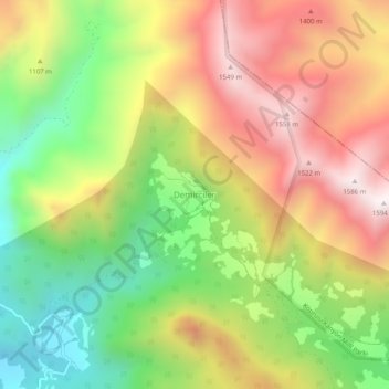
Name: Demirciler topographic map, elevation, terrain.
Location: Demirciler, Serik, Antalya, Mediterranean Region, Turkey (37.20635 31.03979 37.24635 31.07979)
Average elevation: 1,069 m
Minimum elevation: 562 m
Maximum elevation: 1,604 m
Thank you for supporting this site ❤️
Make a donation
Make a donation
Gear up for your next adventure:
As an Amazon Associate, this site earns from qualifying purchases at no extra cost to you.