Geolocate

Adena topographic map

Click on the map to display elevation.

About this map

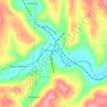
Name: Adena topographic map, elevation, terrain.

Location: Adena, Jefferson County, Ohio, United States (40.21058 -80.89110 40.22537 -80.86581)

Average elevation: 310 m

Minimum elevation: 251 m

Maximum elevation: 376 m

Other topographic maps

Click on a map to view its topography, its elevation and its terrain.

Wolf Run

United States > Ohio > Jefferson County

Average elevation: 359 m

Hammondsville

United States > Ohio > Jefferson County

Average elevation: 293 m

Green Acres

United States > Ohio > Jefferson County

Average elevation: 327 m

La Belle

United States > Ohio > Jefferson County > Steubenville

Average elevation: 267 m

Beechwood

United States > Ohio > Jefferson County > Wintersville

Average elevation: 348 m

Gear up for your next adventure:

🚲Handlebar Phone Mount - View topographic-map.com live while cycling
🏃Hydration Running Vest - Carry water and maps close to your body for speed
🥾Mountaineering Boots - Supportive boots for climbing and high-altitude hiking
👟Sport Hiking Sandals - Breathable footwear for water crossings and camp rest
🧢Hiking Hat - Sun-protective and breathable hats for long treks

As an Amazon Associate, this site earns from qualifying purchases at no extra cost to you.