Geolocate

Boynton topographic map

Click on the map to display elevation.

About this map

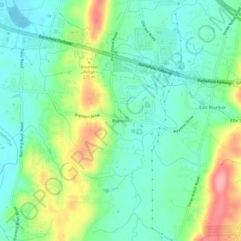
Name: Boynton topographic map, elevation, terrain.

Location: Boynton, Catoosa County, Georgia, 30736, United States (34.90341 -85.21079 34.94341 -85.17079)

Average elevation: 239 m

Minimum elevation: 203 m

Maximum elevation: 315 m

Other topographic maps

Click on a map to view its topography, its elevation and its terrain.

Blue Spring

United States > Georgia > Catoosa County

Average elevation: 236 m

Indian Springs

United States > Georgia > Catoosa County

Average elevation: 236 m

Gear up for your next adventure:

🛌Insulated Sleeping Pad - Critical thermal barrier between you and the cold ground
👟Trail Running Shoes - Agile footwear for fast-paced topographic exploration
🔦LED Headlamp - Hands-free lighting for early morning starts or late finishes
🔋Solar Power Bank - Keep your GPS and devices charged during long outdoor trips
🥾Trail Running Boots - Durable shoes designed for trail running

As an Amazon Associate, this site earns from qualifying purchases at no extra cost to you.