
Sainte-Ursule topographic map
Interactive map
Click on the map to display elevation.
About this map
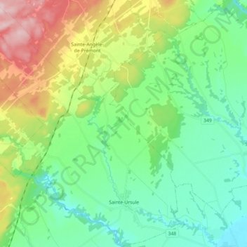
Name: Sainte-Ursule topographic map, elevation, terrain.
Location: Sainte-Ursule, Maskinongé (MRC), Mauricie, Quebec, Canada (46.26362 -73.16160 46.38641 -72.98747)
Average elevation: 90 m
Minimum elevation: 9 m
Maximum elevation: 279 m
Maskinongé (MRC) trails, hiking, mountain biking, running and outdoor activities
Other topographic maps
Click on a map to view its topography, its elevation and its terrain.