
Badger topographic map
Click on the map to display elevation.
About this map
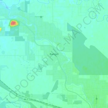
Name: Badger topographic map, elevation, terrain.
Location: Badger, Fairbanks North Star, Alaska, 99705, United States (64.76689 -147.44799 64.84689 -147.36799)
Average elevation: 144 m
Minimum elevation: 135 m
Maximum elevation: 197 m
Other topographic maps
Click on a map to view its topography, its elevation and its terrain.
Fairbanks
United States > Alaska > Fairbanks North Star
Fairbanks is situated within the central Tanana Valley, characterized by a diverse and dynamic topography. The city straddles the Chena River, which flows southwest into the larger Tanana River, defining Fairbanks' southern border. To the north, a gradual incline leads into a chain of hills that ascend toward…
Average elevation: 146 m