Geolocate

Lake View topographic map

Click on the map to display elevation.

About this map

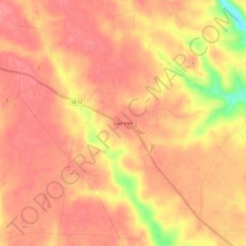
Name: Lake View topographic map, elevation, terrain.

Location: Lake View, Franklin County, Indiana, United States (39.46560 -85.26830 39.50560 -85.22830)

Average elevation: 301 m

Minimum elevation: 238 m

Maximum elevation: 320 m

Other topographic maps

Click on a map to view its topography, its elevation and its terrain.

Oldenburg

United States > Indiana > Franklin County

Average elevation: 288 m

Mount Carmel

United States > Indiana > Franklin County

Average elevation: 307 m

Gear up for your next adventure:

🥾Approach Boots - Comfortable boots for hiking and climbing approaches
🕶️Polarized Sunglasses - Protect your eyes with durable polarized lenses
Camping Tent - Weather-resistant tents suitable for 2 to 6 people
🧳Compression Sacks - Maximize space in your backpack by shrinking gear
🍽️Titanium Camping Spork - Ultralight and indestructible eating utensil

As an Amazon Associate, this site earns from qualifying purchases at no extra cost to you.