
Clomantagh (Mt Garrett) topographic map
Interactive map
Click on the map to display elevation.
About this map
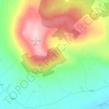
Name: Clomantagh (Mt Garrett) topographic map, elevation, terrain.
Average elevation: 217 m
Minimum elevation: 113 m
Maximum elevation: 349 m
Other topographic maps
Click on a map to view its topography, its elevation and its terrain.
Agha
Agha, Rathcoole, The Municipal District of Castlecomer, Comté de Kilkenny, Leinster, Irlande
Average elevation: 213 m
Tifeaghna (Mt Garrett)
Tifeaghna (Mt Garrett), Lisdowney, The Municipal District of Castlecomer, Comté de Kilkenny, Leinster, Irlande
Average elevation: 145 m
The Municipal District of Kilkenny City
The Municipal District of Kilkenny City, Comté de Kilkenny, Leinster, Irlande
Average elevation: 84 m
Westmoreland
Westmoreland, Aghaviller, The Municipal District of Callan — Thomastown, Comté de Kilkenny, Leinster, Irlande
Average elevation: 134 m
Kilkenny
Kilkenny, Comté de Kilkenny, Leinster, Irlande
Average elevation: 62 m