
North Canadian River topographic map
Interactive map
Click on the map to display elevation.
About this map
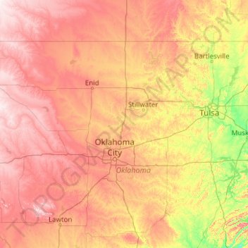
Name: North Canadian River topographic map, elevation, terrain.
Average elevation: 351 m
Minimum elevation: 144 m
Maximum elevation: 717 m
Other topographic maps
Click on a map to view its topography, its elevation and its terrain.
Tillman County
Vereinigte Staaten von Amerika > Oklahoma
Tillman County, Oklahoma, Vereinigte Staaten von Amerika
Average elevation: 366 m
Olustee
Vereinigte Staaten von Amerika > Oklahoma > Jackson County
Olustee, Jackson County, Oklahoma, 73560, Vereinigte Staaten von Amerika
Average elevation: 405 m