Geolocate

Three Brothers topographic map

Click on the map to display elevation.

About this map

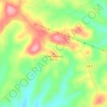
Name: Three Brothers topographic map, elevation, terrain.

Location: Three Brothers, Baxter County, Arkansas, United States (36.47668 -92.48132 36.47678 -92.48122)

Average elevation: 323 m

Minimum elevation: 260 m

Maximum elevation: 398 m

Other topographic maps

Click on a map to view its topography, its elevation and its terrain.

Gassville

United States > Arkansas > Baxter County

Average elevation: 200 m

Salesville

United States > Arkansas > Baxter County

Average elevation: 170 m

Big Flat

United States > Arkansas > Baxter County

Average elevation: 354 m

Norfork Lake

United States > Arkansas > Baxter County

Average elevation: 226 m

Briarcliff

United States > Arkansas > Baxter County

Average elevation: 236 m

Gear up for your next adventure:

🧥Ultralight Puffy Jacket - Maximum warmth that packs down to the size of an orange
🧼Travel Hand Sanitizer - Keep hands clean when water is scarce
🧦Crew Hiking Socks - Comfortable socks for long-distance hikes
🛏️Camping Sleeping Mat - Comfortable mats for sleeping outdoors
🪜Heavy Duty Carabiners - Multi-use clips for securing gear to your backpack

As an Amazon Associate, this site earns from qualifying purchases at no extra cost to you.