Geolocate

Brookhaven topographic map

Click on the map to display elevation.

About this map

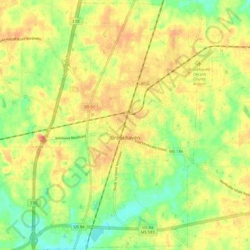
Name: Brookhaven topographic map, elevation, terrain.

Location: Brookhaven, Lincoln County, Mississippi, United States (31.53829 -90.48216 31.62891 -90.39922)

Average elevation: 143 m

Minimum elevation: 118 m

Maximum elevation: 162 m

Gear up for your next adventure:

👟Trail Running Shoes - Agile footwear for fast-paced topographic exploration
🧰Emergency Multi-Tool - Compact multi-tool for outdoor survival
🪑Insulated Seat Pad - Protect your seat from cold rocks and wet logs
📷Outdoor Action Camera - Capture high-elevation views and rugged adventures
Camping Groundsheet - Protect your tent from moisture and dirt

As an Amazon Associate, this site earns from qualifying purchases at no extra cost to you.