Geolocate

Bucal topographic map

Click on the map to display elevation.

About this map

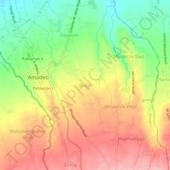
Name: Bucal topographic map, elevation, terrain.

Location: Bucal, Amadeo, Cavite, Calabarzon, 4119, Philippines (14.14793 120.91321 14.18793 120.95321)

Average elevation: 441 m

Minimum elevation: 362 m

Maximum elevation: 512 m

Gear up for your next adventure:

🧰Survival Kit - Essential gear for emergencies in the wilderness
🥾Trail Hiking Boots - Supportive boots for rough trails
🧴Outdoor Sunscreen - High SPF protection for high-altitude UV exposure
🔭Compact Binoculars - Lightweight optics for scouting trails and wildlife
🥘Camping Cookware Set - Compact nesting pots and pans for trail cooking

As an Amazon Associate, this site earns from qualifying purchases at no extra cost to you.