Geolocate

Adrian topographic map

Click on the map to display elevation.

About this map

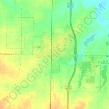
Name: Adrian topographic map, elevation, terrain.

Location: Adrian, Bates County, Missouri, 64720, United States (38.37979 -94.37596 38.40933 -94.32134)

Average elevation: 262 m

Minimum elevation: 243 m

Maximum elevation: 276 m

Other topographic maps

Click on a map to view its topography, its elevation and its terrain.

Altona

United States > Missouri > Bates County

Average elevation: 260 m

Butler City Dam

United States > Missouri > Bates County

Average elevation: 246 m

Virginia

United States > Missouri > Bates County

Average elevation: 264 m

Gear up for your next adventure:

🧢Hiking Hat - Sun-protective and breathable hats for long treks
🥾Approach Boots - Comfortable boots for hiking and climbing approaches
🥾Waterproof Hiking Boots - Essential footwear for rugged terrain and wet Canadian trails
🥾Mountain Hiking Shoes - Shoes with superior grip for mountainous terrain
🎒Hiking Daypack - Lightweight and durable backpacks for day trips and excursions

As an Amazon Associate, this site earns from qualifying purchases at no extra cost to you.