Geolocate

Seymour topographic map

Click on the map to display elevation.

About this map

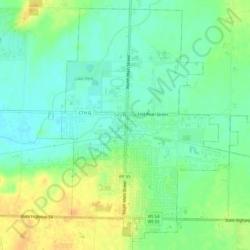
Name: Seymour topographic map, elevation, terrain.

Location: Seymour, Outagamie County, Wisconsin, 54165, United States (44.49738 -88.34527 44.52968 -88.29673)

Average elevation: 247 m

Minimum elevation: 234 m

Maximum elevation: 265 m

Other topographic maps

Click on a map to view its topography, its elevation and its terrain.

Freedom

United States > Wisconsin > Outagamie County

Average elevation: 226 m

Leeman

United States > Wisconsin > Outagamie County

Average elevation: 241 m

Gear up for your next adventure:

🧢Beanie Hat - Keep your head warm in cold weather
❄️Traction Ice Cleats - Slip-on spikes for icy trails and winter hiking
🌡️Emergency Mylar Blankets - Compact thermal protection for unexpected nights outdoors
🧴Outdoor Sunscreen - High SPF protection for high-altitude UV exposure
🧰Emergency Multi-Tool - Compact multi-tool for outdoor survival

As an Amazon Associate, this site earns from qualifying purchases at no extra cost to you.