
Thank you for supporting this site ❤️
Make a donation
Make a donation
Gear up for your next adventure:
As an Amazon Associate, this site earns from qualifying purchases at no extra cost to you.
Cabeçadas topographic map
Click on the map to display elevation.
Thank you for supporting this site ❤️
Make a donation
Make a donation
Gear up for your next adventure:
As an Amazon Associate, this site earns from qualifying purchases at no extra cost to you.
About this map
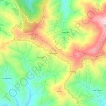
Name: Cabeçadas topographic map, elevation, terrain.
Location: Cabeçadas, Alvares, Góis, Coimbra, 3750-048, Portugal (40.06718 -8.10191 40.10718 -8.06191)
Average elevation: 695 m
Minimum elevation: 460 m
Maximum elevation: 989 m
Thank you for supporting this site ❤️
Make a donation
Make a donation
Gear up for your next adventure:
As an Amazon Associate, this site earns from qualifying purchases at no extra cost to you.