Geolocate

Loretto topographic map

Click on the map to display elevation.

About this map

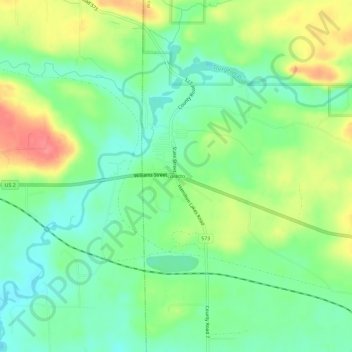
Name: Loretto topographic map, elevation, terrain.

Location: Loretto, Waucedah Township, Dickinson County, Michigan, 49852, United States (45.75718 -87.83513 45.79718 -87.79513)

Average elevation: 279 m

Minimum elevation: 251 m

Maximum elevation: 323 m

Other topographic maps

Click on a map to view its topography, its elevation and its terrain.

Quinnesec

United States > Michigan > Dickinson County

Average elevation: 319 m

Norway

United States > Michigan > Dickinson County

Average elevation: 311 m

Kingsford

United States > Michigan > Dickinson County

Average elevation: 350 m

Gear up for your next adventure:

🧭GPS Tracker - Track your location in remote areas safely
🧦Crew Hiking Socks - Comfortable socks for long-distance hikes
🧥Thermal Layer - Insulating layer for cold outdoor conditions
💡Portable Camping Lamp - Rechargeable lamp for campsite lighting
🚲Heavy Duty Bike Lock - Secure your bike at the trailhead or during stops

As an Amazon Associate, this site earns from qualifying purchases at no extra cost to you.