
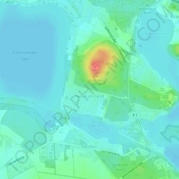
Neu Fahrland topographic map
Interactive map
Click on the map to display elevation.
About this map
Name: Neu Fahrland topographic map, elevation, terrain.
Location: Neu Fahrland, Potsdam, Brandenburg, Deutschland (52.43531 13.02445 52.45715 13.06413)
Average elevation: 36 m
Minimum elevation: 26 m
Maximum elevation: 80 m
Der Kirchberg ist ein Waldgebiet mit ausgebauten und markierten Wanderwegen. Erdgeschichtlich stellt er den Rest einer eiszeitlichen Endmoräne dar. Er ist die höchste Erhebung im Nahbereich: 85 m ü. NN, das sind hier ca. 35 m sichtbare Höhe, da der Fuß des Hügels auf einer Höhe von etwa 50 m ü. NN liegt. Einen Aussichtspunkt gibt es wieder seit 2005.
Other topographic maps
Click on a map to view its topography, its elevation and its terrain.
Nedlitz
Deutschland > Brandenburg > Potsdam > Neu Fahrland
Nedlitz, Potsdam Nord, Neu Fahrland, Potsdam, Brandenburg, 14469, Deutschland
Average elevation: 40 m