
Make a donation
Gear up for your next adventure:
As an Amazon Associate, this site earns from qualifying purchases at no extra cost to you.
Wolseley topographic map
Click on the map to display elevation.
Make a donation
Gear up for your next adventure:
As an Amazon Associate, this site earns from qualifying purchases at no extra cost to you.
Wolseley
Wolseley lies at an altitude of 260 metres (850 ft) on the watershed between the drainage basins of the Breede River, which flows south to the Indian Ocean, and the Berg River, which flows north to the Atlantic Ocean. It is 15 kilometres (9 mi) south of Tulbagh, 12 kilometres (7 mi) southwest of Ceres, and 35 kilometres (22 mi) northwest of Worcester.
Make a donation
Gear up for your next adventure:
As an Amazon Associate, this site earns from qualifying purchases at no extra cost to you.
About this map
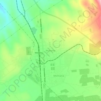
Name: Wolseley topographic map, elevation, terrain.
Average elevation: 271 m
Minimum elevation: 205 m
Maximum elevation: 371 m
Make a donation
Gear up for your next adventure:
As an Amazon Associate, this site earns from qualifying purchases at no extra cost to you.
Other topographic maps
Click on a map to view its topography, its elevation and its terrain.
Witzenberg Ward 9
South Africa > Western Cape > Cape Winelands District Municipality > Witzenberg Local Municipality
Average elevation: 892 m
Tankwa Town
South Africa > Western Cape > Cape Winelands District Municipality > Witzenberg Local Municipality
Average elevation: 477 m