Geolocate

Granda topographic map

Click on the map to display elevation.

About this map

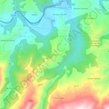
Name: Granda topographic map, elevation, terrain.

Location: Granda, Parres, Asturias, 33559, Spain (43.33007 -5.20742 43.37007 -5.16742)

Average elevation: 200 m

Minimum elevation: 32 m

Maximum elevation: 519 m

Gear up for your next adventure:

🥾Mountain Trail Shoes - High-traction shoes for mountain trails
🌡️Emergency Mylar Blankets - Compact thermal protection for unexpected nights outdoors
💡LED Camping Lantern - Illuminate your campsite with long-lasting lanterns
🥾Mountain Hiking Boots - High-traction boots for rocky terrain
🚑Survival Whistle - Signal for help across long distances in mountains

As an Amazon Associate, this site earns from qualifying purchases at no extra cost to you.