
Make a donation
Gear up for your next adventure:
As an Amazon Associate, this site earns from qualifying purchases at no extra cost to you.
Happy Valley Reservoir topographic map
Click on the map to display elevation.
Make a donation
Gear up for your next adventure:
As an Amazon Associate, this site earns from qualifying purchases at no extra cost to you.
About this map
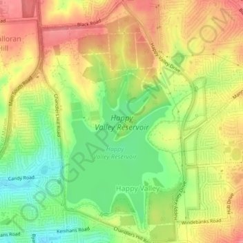
Name: Happy Valley Reservoir topographic map, elevation, terrain.
Average elevation: 164 m
Minimum elevation: 121 m
Maximum elevation: 201 m
Make a donation
Gear up for your next adventure:
As an Amazon Associate, this site earns from qualifying purchases at no extra cost to you.
Other topographic maps
Click on a map to view its topography, its elevation and its terrain.
Make a donation
Gear up for your next adventure:
As an Amazon Associate, this site earns from qualifying purchases at no extra cost to you.
Make a donation
Gear up for your next adventure:
As an Amazon Associate, this site earns from qualifying purchases at no extra cost to you.
Onkaparinga River National Park
Australia > South Australia > City of Onkaparinga > Adelaide
Average elevation: 139 m
Make a donation
Gear up for your next adventure:
As an Amazon Associate, this site earns from qualifying purchases at no extra cost to you.
Coromandel Valley
Australia > South Australia > City of Onkaparinga > Adelaide
Average elevation: 248 m
Make a donation
Gear up for your next adventure:
As an Amazon Associate, this site earns from qualifying purchases at no extra cost to you.
Huntfield Heights
Australia > South Australia > City of Onkaparinga > Adelaide
Average elevation: 62 m
Onkaparinga Hills
Australia > South Australia > City of Onkaparinga > Adelaide
Average elevation: 179 m
Make a donation
Gear up for your next adventure:
As an Amazon Associate, this site earns from qualifying purchases at no extra cost to you.
Make a donation
Gear up for your next adventure:
As an Amazon Associate, this site earns from qualifying purchases at no extra cost to you.
Aldinga Conservation Park
Australia > South Australia > City of Onkaparinga > Adelaide
Average elevation: 16 m
Make a donation
Gear up for your next adventure:
As an Amazon Associate, this site earns from qualifying purchases at no extra cost to you.
Make a donation
Gear up for your next adventure:
As an Amazon Associate, this site earns from qualifying purchases at no extra cost to you.
Adelaide (Sellicks Hill) Weather Radar
Australia > South Australia > City of Onkaparinga > Adelaide
Average elevation: 291 m
Huntfield Heights
Australia > South Australia > City of Onkaparinga > Adelaide
Average elevation: 62 m
Make a donation
Gear up for your next adventure:
As an Amazon Associate, this site earns from qualifying purchases at no extra cost to you.
Make a donation
Gear up for your next adventure:
As an Amazon Associate, this site earns from qualifying purchases at no extra cost to you.
Port Noarlunga South
Australia > South Australia > City of Onkaparinga > Adelaide
Average elevation: 9 m
Onkaparinga Hills
Australia > South Australia > City of Onkaparinga > Adelaide
Average elevation: 179 m
Make a donation
Gear up for your next adventure:
As an Amazon Associate, this site earns from qualifying purchases at no extra cost to you.