
Puente Caporal topographic map
Interactive map
Click on the map to display elevation.
About this map
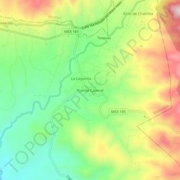
Name: Puente Caporal topographic map, elevation, terrain.
Location: Puente Caporal, Malinalco, 52440, México (18.88140 -99.47333 18.92140 -99.43333)
Average elevation: 1,545 m
Minimum elevation: 1,370 m
Maximum elevation: 1,782 m
Other topographic maps
Click on a map to view its topography, its elevation and its terrain.