
Thank you for supporting this site ❤️
Make a donation
Make a donation
Gear up for your next adventure:
As an Amazon Associate, this site earns from qualifying purchases at no extra cost to you.
La Arenosa topographic map
Click on the map to display elevation.
Thank you for supporting this site ❤️
Make a donation
Make a donation
Gear up for your next adventure:
As an Amazon Associate, this site earns from qualifying purchases at no extra cost to you.
About this map
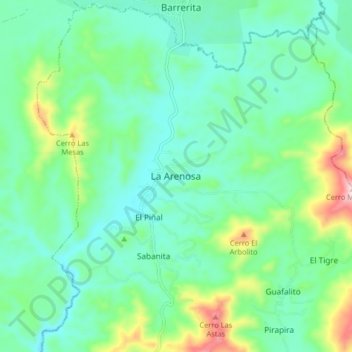
Name: La Arenosa topographic map, elevation, terrain.
Average elevation: 468 m
Minimum elevation: 379 m
Maximum elevation: 743 m
Thank you for supporting this site ❤️
Make a donation
Make a donation
Gear up for your next adventure:
As an Amazon Associate, this site earns from qualifying purchases at no extra cost to you.
Other topographic maps
Click on a map to view its topography, its elevation and its terrain.
Parroquia Tocuyito
Venezuela > Estado Carabobo > Municipio Libertador
Está ubicado en las Sabanas de Carabobo, a una altitud de 451 metros con una temperatura promedio anual de 26 °C.
Average elevation: 623 m