Geolocate

Bawi topographic map

Click on the map to display elevation.

About this map

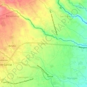
Name: Bawi topographic map, elevation, terrain.

Location: Bawi, Padre Garcia, Batangas, Calabarzon, 4224, Philippines (13.86712 121.21289 13.90712 121.25289)

Average elevation: 156 m

Minimum elevation: 111 m

Maximum elevation: 202 m

Other topographic maps

Click on a map to view its topography, its elevation and its terrain.

San Miguel

Philippines > Batangas > Padre Garcia

Average elevation: 181 m

Bukal

Philippines > Batangas > Padre Garcia

Average elevation: 120 m

Tangob

Philippines > Batangas > Padre Garcia

Average elevation: 116 m

Quilo-quilo North

Philippines > Batangas > Padre Garcia

Average elevation: 152 m

Payapa

Philippines > Batangas > Padre Garcia

Average elevation: 139 m

Tamak

Philippines > Batangas > Padre Garcia

Average elevation: 147 m

Banaba

Philippines > Batangas > Padre Garcia

Average elevation: 174 m

Pansol

Philippines > Batangas > Padre Garcia

Average elevation: 136 m

Gear up for your next adventure:

🥾Mountain Hiking Shoes - Shoes with superior grip for mountainous terrain
🥾Lightweight Hiking Boots - Boots for comfort and mobility on long hikes
🧼Travel Hand Sanitizer - Keep hands clean when water is scarce
🎒Hiking Backpack - Lightweight and ergonomic backpacks for day hikes or multi-day treks
🚲Handlebar Phone Mount - View topographic-map.com live while cycling

As an Amazon Associate, this site earns from qualifying purchases at no extra cost to you.