
Spragge topographic map
Click on the map to display elevation.
About this map
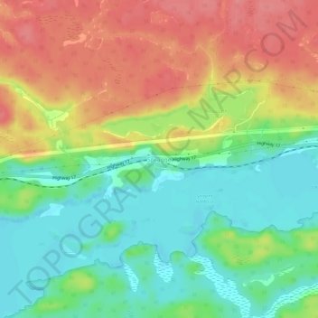
Name: Spragge topographic map, elevation, terrain.
Average elevation: 208 m
Minimum elevation: 171 m
Maximum elevation: 252 m
Algoma District trails, hiking, mountain biking, running and outdoor activities
Other topographic maps
Click on a map to view its topography, its elevation and its terrain.
Lauzon Lake
Canada > Ontario > Algoma District > The North Shore Township > Algoma Mills
Average elevation: 210 m