
Cortenaz topographic map
Click on the map to display elevation.
About this map
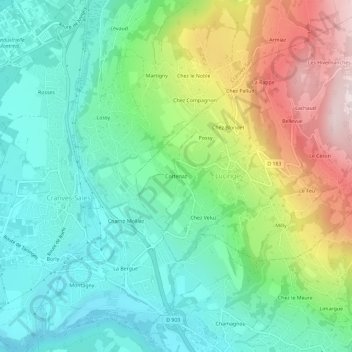
Name: Cortenaz topographic map, elevation, terrain.
Average elevation: 656 m
Minimum elevation: 455 m
Maximum elevation: 1,076 m
Other topographic maps
Click on a map to view its topography, its elevation and its terrain.
Les Voirons
France > Auvergne-Rhône-Alpes > Haute-Savoie > Lucinges
Le flanc est correspond à la pente structurale du flysch des Voirons, c'est-à-dire que la topographie suit le pendage des couches. La formation du grès des Voirons affleurant sur la moitié supérieure cède la place à la formation du conglomérat du Vouan dans sa moitié inférieure. Cette dernière est…
Average elevation: 994 m