Geolocate

Mimbalot topographic map

Click on the map to display elevation.

About this map

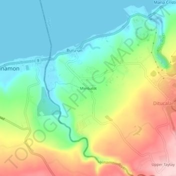
Name: Mimbalot topographic map, elevation, terrain.

Location: Mimbalot, Iligan, Northern Mindanao, 9201, Philippines (8.15945 124.15538 8.19945 124.19538)

Average elevation: 94 m

Minimum elevation: 0 m

Maximum elevation: 261 m

Other topographic maps

Click on a map to view its topography, its elevation and its terrain.

Digkila-an

Philippines > Iligan

Average elevation: 151 m

Agus River

Philippines > Iligan > Ditucalan > Upper Taytay

Average elevation: 234 m

Gear up for your next adventure:

🥾Trail Hiking Shoes - Durable shoes designed for rugged trails
💧Hydration Pack - Hands-free hydration system for long hikes
🥾Waterproof Hiking Shoes - Durable shoes for wet and rugged trails
🥾Mountain Hiking Shoes - Shoes with superior grip for mountainous terrain
🏃Hydration Running Vest - Carry water and maps close to your body for speed

As an Amazon Associate, this site earns from qualifying purchases at no extra cost to you.