Geolocate

Soy topographic map

Click on the map to display elevation.

About this map

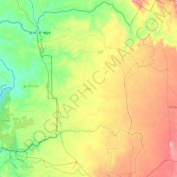
Name: Soy topographic map, elevation, terrain.

Location: Soy, Uasin Gishu County, Rift Valley, Kenya (0.57653 35.11328 0.94332 35.37905)

Average elevation: 1,973 m

Minimum elevation: 1,715 m

Maximum elevation: 2,391 m

Gear up for your next adventure:

🥾Trail Hiking Boots - Supportive boots for rough trails
Camping Tent - Weather-resistant tents suitable for 2 to 6 people
🔭Compact Binoculars - Lightweight optics for scouting trails and wildlife
🎒Fully Waterproof Backpack - Total protection for photography gear and electronics
🥾Durable Hiking Shoes - Long-lasting shoes for frequent hiking

As an Amazon Associate, this site earns from qualifying purchases at no extra cost to you.