
Make a donation
Gear up for your next adventure:
As an Amazon Associate, this site earns from qualifying purchases at no extra cost to you.
Hazleton topographic map
Click on the map to display elevation.
Make a donation
Gear up for your next adventure:
As an Amazon Associate, this site earns from qualifying purchases at no extra cost to you.
Hazleton
In 1818, anthracite coal deposits were discovered in nearby Beaver Meadows by prospectors Nathaniel Beach and Tench Coxe. This caught the attention of railroad developers in Philadelphia. A young engineer from New York named Ariovistus "Ario" Pardee was hired to survey the topography of Beaver Meadows and report the practicality of extending a railroad from the Lehigh Canal in Jim Thorpe to Beaver Meadows. Knowing that the area of Beaver Meadows was already controlled by Coxe and Beach, Pardee bought many acres of the land in present-day Hazleton. The investment proved to be lucrative. The land contained part of a massive anthracite coal field. Pardee is known as the founding father of Hazleton because of these contributions and initially laying out the patch town that eventually became Hazleton.
Make a donation
Gear up for your next adventure:
As an Amazon Associate, this site earns from qualifying purchases at no extra cost to you.
About this map
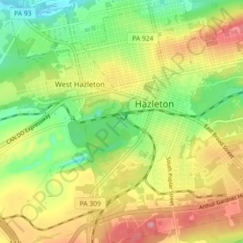
Name: Hazleton topographic map, elevation, terrain.
Location: Hazleton, Luzerne County, Pennsylvania, 18201, United States (40.92801 -75.99645 40.97487 -75.94580)
Average elevation: 510 m
Minimum elevation: 442 m
Maximum elevation: 591 m
Make a donation
Gear up for your next adventure:
As an Amazon Associate, this site earns from qualifying purchases at no extra cost to you.
Other topographic maps
Click on a map to view its topography, its elevation and its terrain.
Make a donation
Gear up for your next adventure:
As an Amazon Associate, this site earns from qualifying purchases at no extra cost to you.
Make a donation
Gear up for your next adventure:
As an Amazon Associate, this site earns from qualifying purchases at no extra cost to you.
Glen Summit
United States > Pennsylvania > Luzerne County > Fairview Township
Average elevation: 539 m
Roaring Brook
United States > Pennsylvania > Luzerne County > Hunlock Township
Average elevation: 337 m
Make a donation
Gear up for your next adventure:
As an Amazon Associate, this site earns from qualifying purchases at no extra cost to you.
Wapwallopen
United States > Pennsylvania > Luzerne County > Conyngham Township
Average elevation: 223 m
Town Hill
United States > Pennsylvania > Luzerne County > Huntington Township
Average elevation: 281 m
Make a donation
Gear up for your next adventure:
As an Amazon Associate, this site earns from qualifying purchases at no extra cost to you.
Huntington Mills
United States > Pennsylvania > Luzerne County > Huntington Township
Average elevation: 289 m
Make a donation
Gear up for your next adventure:
As an Amazon Associate, this site earns from qualifying purchases at no extra cost to you.
Make a donation
Gear up for your next adventure:
As an Amazon Associate, this site earns from qualifying purchases at no extra cost to you.
Liewellyn Corners
United States > Pennsylvania > Luzerne County > Bear Creek Township
Average elevation: 449 m
Hunlock Creek
United States > Pennsylvania > Luzerne County > Hunlock Township > Hunlock
Average elevation: 276 m
Make a donation
Gear up for your next adventure:
As an Amazon Associate, this site earns from qualifying purchases at no extra cost to you.
Wapwallopen
United States > Pennsylvania > Luzerne County > Conyngham Township
Average elevation: 223 m
Fern Glen
United States > Pennsylvania > Luzerne County > Black Creek Township
Average elevation: 391 m
Make a donation
Gear up for your next adventure:
As an Amazon Associate, this site earns from qualifying purchases at no extra cost to you.
South Pond Dam
United States > Pennsylvania > Luzerne County > Hanover Township
Average elevation: 204 m
Ricketts Glen State Park
United States > Pennsylvania > Luzerne County > Fairmount Township
The state's original plans for the new park included building an inn, an 18-hole golf course and country club, and a winter sports complex for skiing, ice boating, and tobogganing, as well as a beach with bathing facilities, cabins, and a tent camping area. Only the last three were actually built, all south of…
Average elevation: 588 m
Make a donation
Gear up for your next adventure:
As an Amazon Associate, this site earns from qualifying purchases at no extra cost to you.
Fern Glen
United States > Pennsylvania > Luzerne County > Black Creek Township
Average elevation: 391 m
Make a donation
Gear up for your next adventure:
As an Amazon Associate, this site earns from qualifying purchases at no extra cost to you.