Geolocate

DeWitt topographic map

Click on the map to display elevation.

About this map

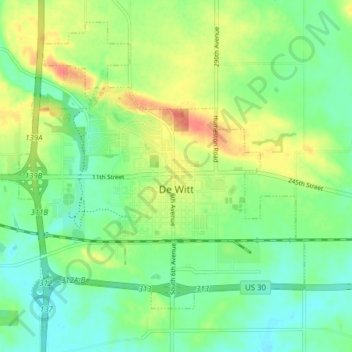
Name: DeWitt topographic map, elevation, terrain.

Location: DeWitt, Clinton County, Iowa, United States (41.80034 -90.58761 41.85108 -90.51003)

Average elevation: 209 m

Minimum elevation: 189 m

Maximum elevation: 240 m

Other topographic maps

Click on a map to view its topography, its elevation and its terrain.

Adams Island

United States > Iowa > Clinton County

Average elevation: 179 m

Gear up for your next adventure:

🥾Waterproof Hiking Boots - Boots keeping your feet dry in wet conditions
🔭Compact Binoculars - Lightweight optics for scouting trails and wildlife
🧶550 Survival Paracord - Versatile utility cord for emergency repairs and rigging
🔪Outdoor Multitool - Versatile tool for repairs and food prep in the wild
💧Reusable Water Bottle - Durable water bottles for hydration on trails

As an Amazon Associate, this site earns from qualifying purchases at no extra cost to you.