
Le Célas topographic map
Interactive map
Click on the map to display elevation.
About this map
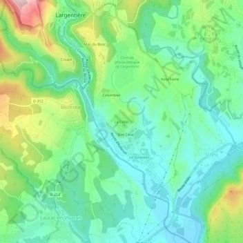
Name: Le Célas topographic map, elevation, terrain.
Average elevation: 225 m
Minimum elevation: 141 m
Maximum elevation: 425 m
Other topographic maps
Click on a map to view its topography, its elevation and its terrain.
Coupe
France > Auvergne-Rhône-Alpes > Ardèche > Largentière
Coupe, Largentière, Ardèche, Auvergne-Rhône-Alpes, France métropolitaine, 07110, France
Average elevation: 282 m
Mas du Bosc
France > Auvergne-Rhône-Alpes > Ardèche > Largentière
Mas du Bosc, Largentière, Ardèche, Auvergne-Rhône-Alpes, France métropolitaine, 07110, France
Average elevation: 273 m