Geolocate

Chicken Island topographic map

Click on the map to display elevation.

About this map

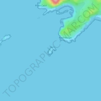
Name: Chicken Island topographic map, elevation, terrain.

Location: Chicken Island, Huon Valley, Tasmania, Australia (-43.57239 146.60144 -43.57054 146.60409)

Average elevation: 4 m

Minimum elevation: -4 m

Maximum elevation: 120 m

Other topographic maps

Click on a map to view its topography, its elevation and its terrain.

Frog Hill

Australia > Tasmania

Average elevation: 875 m

Mount Kate

Australia > Tasmania

Average elevation: 995 m

Tasman Peninsula

Australia > Tasmania > Tasman > Fortescue

Average elevation: 167 m

Mount Jukes

Australia > Tasmania

Average elevation: 773 m

Ulverstone

Australia > Tasmania > Ulverstone

Average elevation: 37 m

Bullock Hill

Australia > Tasmania > Grove

Average elevation: 147 m

Highland Waters

Australia > Tasmania > London Lakes

Average elevation: 759 m

Stillwater Hill

Australia > Tasmania

Average elevation: 353 m

Legges Tor

Australia > Tasmania

Average elevation: 1,457 m

Rowlands Hill

Australia > Tasmania

Average elevation: 388 m

Recherche Bay

Australia > Tasmania

Average elevation: 10 m

Bastyan Dam

Australia > Tasmania > Tullah

Average elevation: 233 m

Gear up for your next adventure:

💧Reusable Water Bottle - Durable water bottles for hydration on trails
🥾All-Terrain Hiking Boots - Versatile boots for varied hiking conditions
🧳Compression Sacks - Maximize space in your backpack by shrinking gear
🥾Trail Running Boots - Durable shoes designed for trail running
🥾Hiking Shorts - Breathable shorts suitable for summer hikes

As an Amazon Associate, this site earns from qualifying purchases at no extra cost to you.