
Stephenson topographic map
Click on the map to display elevation.
About this map
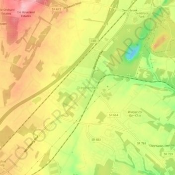
Name: Stephenson topographic map, elevation, terrain.
Location: Stephenson, Frederick County, Virginia, 22624, United States (39.21884 -78.12846 39.25884 -78.08846)
Average elevation: 195 m
Minimum elevation: 116 m
Maximum elevation: 253 m
Other topographic maps
Click on a map to view its topography, its elevation and its terrain.
Kernstown Battlefield Park
United States > Virginia > Frederick County > Winchester > Valley Acres
Average elevation: 241 m